
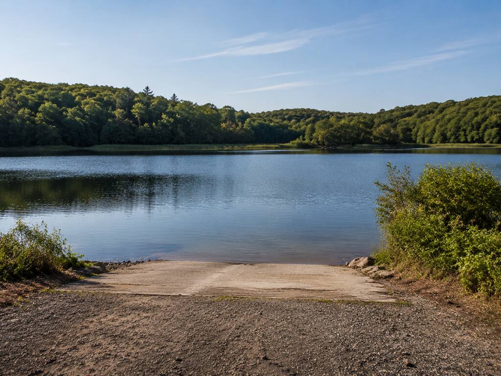
Woonasquatucket Reservoir—better known locally as Stump Pond—offers a state-owned public boat ramp and freshwater fishing access in Smithfield, Rhode Island. Rhode Island DEM lists the reservoir at 304 acres, confirms parking, identifies a slab ramp and sets a 10-horsepower limit. This practical guide covers the Log Road approach, launching, fishing rules, invasive-plant precautions and the planning details the official directory does—and does not—publish.
Stump Pond access at a glance
- Official waterbody name: Woonasquatucket Reservoir
- Common name: Stump Pond; some official assessment records also use Stillwater Reservoir
- Town: Smithfield, Rhode Island
- Published size: 304 acres in the current Rhode Island DEM boat-launching directory
- Official approach: Route 5 to Log Road
- Ownership and operation: State-owned and state-operated
- Ramp: Slab ramp
- Parking: Yes; no capacity, striping, trailer layout or overnight-parking policy is published
- Motor restriction: 10-horsepower limit
- Best fit: Small fishing boats, canoes and kayaks that can comply with the horsepower limit
Finding the Log Road boat ramp
Rhode Island DEM’s public launch directory gives the official approach as Route 5 to Log Road. The agency does not publish a numbered street address for the ramp. Use the final map for orientation, then watch for current public-access signs and avoid turning into private waterfront driveways.
Log Road connects with Route 5 in Smithfield, west of the main Providence urban area. Cell navigation can be useful, but a pin is not proof that a driveway or shoreline is public. The state directory is the authority for the public launch; posted signs and any temporary barriers control conditions when you arrive.
Parking and slab-ramp conditions
The state confirms parking and a slab ramp but does not describe the number of spaces, ramp width, slope, water depth, dock, turnaround geometry or trailer capacity. That matters: a formal slab does not guarantee that every tow vehicle, trailer or water level will be easy to manage.
- Prepare plugs, lines, straps and safety equipment before occupying the ramp.
- Walk the visible portion of the slab and check for algae, mud, leaves, ice, erosion or a submerged drop-off.
- Confirm adequate water depth for your boat and trailer; no official ramp-depth measurement is published.
- Use a spotter when backing and keep children and bystanders away from the vehicle path.
- Move to a legal parking space promptly after launching so the access remains usable.
- Never block a gate, emergency route, turnaround, nearby driveway or another trailer.
The 10-horsepower rule
Rhode Island DEM lists a 10 HP limit for Woonasquatucket Reservoir. Treat that as a restriction on the waterbody, not merely a suggestion for the ramp. A larger motor mounted on a boat may create a compliance issue even if it is not being used, so confirm the current interpretation with DEM before towing a boat powered above the published limit.
All statewide registration, personal-flotation-device, lighting and safe-operation requirements still apply. A horsepower limit does not make the reservoir hazard-free: wind, submerged wood, vegetation, changing depth and other users can affect a small boat quickly.
Fishing Stump Pond without guessing at species
Stump Pond is a public freshwater fishing destination, but the current official launch record does not provide a dependable site-specific species list. Rather than repeat unsourced fish claims, plan around the habitat you can observe and the regulations that apply on the day of your trip. Bring more than one presentation, work shoreline changes and vegetation edges carefully, and adjust to water clarity, temperature and wind.
Review the active Rhode Island freshwater fishing regulations and the state’s freshwater sizes and limits before fishing. A Rhode Island fishing license may be required depending on age and residency. Carry the current rules rather than relying on an old screenshot or a general lake summary.
Mercury and fish-consumption planning
Rhode Island’s 2024 integrated water-quality report identifies Woonasquatucket Reservoir under waterbody ID RI0002007L-08 and lists mercury in fish tissue as an impairment. That does not mean fishing is closed, but it makes current fish-consumption guidance important—especially for pregnant people, children and anyone who eats locally caught fish often.
Check Rhode Island’s current health and DEM guidance before keeping fish. Catch-and-release anglers should still handle fish quickly, wet their hands before contact and minimize time out of water.
Aquatic plants: clean every boat and trailer
Official Rhode Island invasive-plant material documents fanwort and variable milfoil in Woonasquatucket Reservoir. The state’s water-chestnut distribution map also records Stump Pond, with a first documented date of July 22, 2024 and a last-surveyed date of August 14, 2024. Those records show why cleaning gear is part of responsible trip planning; they do not predict plant density at the ramp on a particular day.
- Remove visible plants, mud and animals from the hull, propeller, lower unit, trailer, anchor and fishing gear.
- Drain livewells, bilges and other water-holding compartments where legal and safe.
- Do not move plants or water to another lake or river.
- Inspect paddles, pedal drives and kayak scuppers before leaving.
- If dense vegetation makes launching unsafe, choose another access rather than forcing a trailer or motor through it.
Cyanobacteria and changing water conditions
Warm, calm weather can produce harmful cyanobacteria blooms in Rhode Island waters. No destination-specific closure is asserted here because advisories change. Check the Rhode Island harmful-algae dashboard immediately before visiting. Avoid discolored water, surface scum, unusual odors and areas with dead fish, and keep pets away from suspect water.
Facilities, accessibility and trip preparation
The official launch directory confirms parking and the slab ramp but does not document restrooms, potable water, lighting, a courtesy dock, trash service, launch fees or measured accessible features. Plan as if services are limited: arrive with drinking water, weather protection, a charged phone, first-aid supplies and everything needed to pack out your trash.
- Tell someone your launch point and return time.
- Wear a properly fitted life jacket; do not merely store it out of reach.
- Check wind and thunderstorms before leaving shore.
- Carry a whistle and navigation light if low-light conditions are possible.
- Keep speed and wake conservative around paddlers, anglers and shorelines.
- Leave if water level, ramp traction, weather or parking conditions are unsuitable.
Nearby Rhode Island alternatives
- Upper Slatersville Reservoir offers another state slab ramp in northern Rhode Island, with no special horsepower restriction listed in the launch directory.
- Wilson Reservoir has a state-owned East Wallum Lake Road access and a published 10-hp limit.
- Pascoag Reservoir (Echo Lake) has an accessible state ramp and seasonal motor guidance.
Official planning sources
- Rhode Island DEM public boat-launching directory
- Rhode Island 2024 integrated water-quality report
- Rhode Island DEM water-chestnut distribution map
- Active Rhode Island freshwater fishing regulations
Information was verified August 30, 2026. Access, parking, water level, vegetation, advisories and regulations can change; follow official notices and posted signs immediately before visiting.


Leave a Reply