
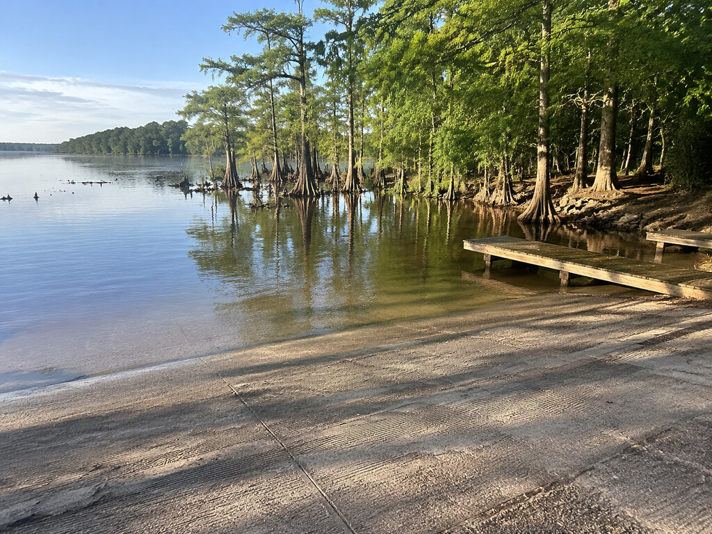
Low Falls Landing is a public boat ramp on upper Lake Marion in Calhoun County, South Carolina, near Lone Star and the Elloree area. It is a practical launch for anglers and small-boat users reaching the wooded upper reservoir, but the trip deserves more preparation than a typical open-lake ramp: water levels change, submerged timber is widespread, and the landing sits at the end of a rural road.
Low Falls Landing at a glance
- Waterbody: Upper Lake Marion, close to the Santee River reach
- Area: Lone Star / Elloree area, Calhoun County, South Carolina
- Road access: End of Low Falls Road, state secondary route S-9-129
- Primary use: Public trailered-boat launching, fishing access and paddling
- Ownership: Santee Cooper, as documented in the SCDNR ramp inventory
- Current listing: Low Falls Landing appears in South Carolina’s official public-ramp inventory and Lake Marion access directory
- Facilities: The historical agency ramp record documents paved parking, multiple launch lanes and courtesy docks; verify present conditions and availability on arrival
- Shore fishing: No official fishing pier is documented, and dependable bank access is not promised
How to reach Low Falls Landing
Approach from the Lone Star area and follow Low Falls Road, S-9-129, to the public landing at approximately 33.63238, -80.54350. The official public-ramp listing places Low Falls Landing in Calhoun County; an older state ramp directory associates it with the Elloree area. Some navigation services use Cameron as the mailing city, so the exact landing name and coordinates are more dependable than searching only by city.
Download the route before leaving reliable cellular coverage. The final approach is rural, and a map pin in open water can route a driver incorrectly. Slow down near the end of the road, follow posted landing signs and preserve space for vehicles towing trailers.
Ramp and parking conditions
The SCDNR dataset is the best structured discovery source for Low Falls Landing. Its older facility details describe a public, paved launch with four lanes, three courtesy docks and paved trailer parking. Because the underlying ramp-detail data predates this visit-planning guide, treat those counts as historical orientation rather than a guarantee that every lane, dock or space is currently usable.
- Pause before backing down and inspect the ramp surface, waterline, debris and dock condition.
- Prepare plugs, straps, lines and safety gear away from the active launch lanes.
- Park only in marked spaces and never block the turnaround or dock approach.
- Expect busy conditions on favorable fishing weekends and arrive with a backup landing in mind.
- Do not assume restrooms, drinking water, lighting, accessible features or overnight parking are available unless posted on site.
- Water level can change how much usable ramp remains below the trailer.
Boat access versus shore access
Low Falls Landing is primarily a boat-launch destination. The official ramp record does not document a fishing pier, and shoreline fishing space can be limited by docks, launch traffic, vegetation and fluctuating water. Do not fish from an active ramp lane or a courtesy dock when doing so interferes with launching.
Canoes and kayaks can use the public access, but paddlers should launch efficiently and remain highly visible around trailered boats. A bright personal flotation device, whistle and white light for low-light conditions are sensible even for a short trip.
Fishing upper Lake Marion
SCDNR describes Lake Marion’s stumps, dead trunks and live cypress as productive habitat for crappie, bream and catfish. Native vegetation along sloping shorelines and backwater sloughs also supports largemouth bass, pickerel and other species. Low Falls Landing gives boat anglers access to that upper-lake cover without targeting the same visitor intent as a park or fishing pier.
Early September can still bring heat and warm water. Fish activity, depth and current can change with weather and reservoir operations, so use current conditions rather than a fixed seasonal promise. The SCDNR freshwater fishing trends provide timely regional context, but they do not replace on-water judgment.
Licenses and current regulations
Review the 2026–2027 South Carolina hunting and fishing regulations before casting. Anglers age 16 and older generally need the appropriate freshwater fishing license. Lake Marion has species-specific size and creel limits, and nongame devices can require separate licenses, tags, markings or location rules. Carry the current guide rather than relying on an old screenshot or memory.
The landing does not create special permission to enter private shoreline, docks or adjacent land. Remain within the public access footprint and navigable water unless another area is clearly posted open.
Submerged timber and navigation
Lake Marion was impounded before all timber was cleared. SCDNR warns that thousands of stumps, dead tree trunks and live cypress remain, while Santee Cooper advises boaters to stay between marked navigation aids and use caution outside the channel. A calm surface does not mean the route is clear beneath the boat.
- Idle away from the ramp until depth and hazards are understood.
- Keep a proper lookout for stumps, floating wood, anglers, paddlers and changing channel markers.
- Do not follow another boat blindly; its draft and operator knowledge may differ.
- Carry a paddle or other backup propulsion appropriate to the vessel.
- Use offline navigation and mark the landing before leaving it.
- Return before darkness if the route is unfamiliar.
Lake level, weather and boating safety
Santee Cooper manages Lake Marion around a seasonal rule curve. Check the utility’s current lake-data page before towing to the landing because changing elevation can expose stumps, reduce usable ramp depth or conceal hazards. Recent rain upstream can also affect inflow and floating debris.
South Carolina thunderstorms can develop quickly in late summer. If thunder is audible, get off the water. Carry more drinking water than a short trip seems to require, use sun and insect protection, and leave a float plan with someone ashore.
SCDNR requires one wearable U.S. Coast Guard-approved life jacket for every person aboard. It must fit, remain serviceable and be readily accessible. Children under 12 must wear an approved life jacket while aboard a boat shorter than 16 feet. Wearing one is the safer choice for everyone around submerged timber and deep, turbid water.
Clean, drain and dry
Santee Cooper monitors and treats invasive aquatic vegetation including hydrilla, water hyacinth, giant salvinia and crested floating heart. Before leaving, remove plants, mud and fishing line from the boat, trailer, anchor and gear. Drain live wells, bilges and other water-holding compartments where legal, then dry equipment before entering another waterbody.
Nearby Lake Marion alternatives
Sparkleberry Landing is the stronger choice for a trip centered on upper-lake swamp paddling. Taw Caw Creek Park adds fishing piers, a boardwalk and county-park amenities. C. Alex Harvin III Landing provides a distinct SC-260 launch farther southeast. Check current conditions at each rather than assuming one landing is a like-for-like substitute.
Before-you-go checklist
- Confirm the landing is open and Low Falls Road is passable.
- Check Lake Marion elevation, recent rain, wind and thunderstorms.
- Verify ramp depth, dock condition and available trailer parking on arrival.
- Bring required registration, lights and safety equipment.
- Carry the current fishing license and 2026–2027 regulations.
- Save the landing coordinates and an offline return route.
- Bring a backup destination if the ramp or parking area is crowded.
Official planning sources
- SCDNR Boat Ramps FeatureServer
- SCDNR public boat-ramp map
- South Carolina Public Fishing Access
- SCDNR Lake Marion description and access information
- Santee Cooper lakes and navigation guidance
- Santee Cooper lake data and FAQs
- SCDNR boating safety guidance
- 2026–2027 South Carolina regulations
Information was verified September 1, 2026. The landing’s name, Calhoun County location and public-ramp role are supported by official South Carolina sources. Detailed lane, dock and parking counts come from an older SCDNR facility record and should be rechecked on site. Water level, ramp condition, rules and temporary closures can change.


Leave a Reply