
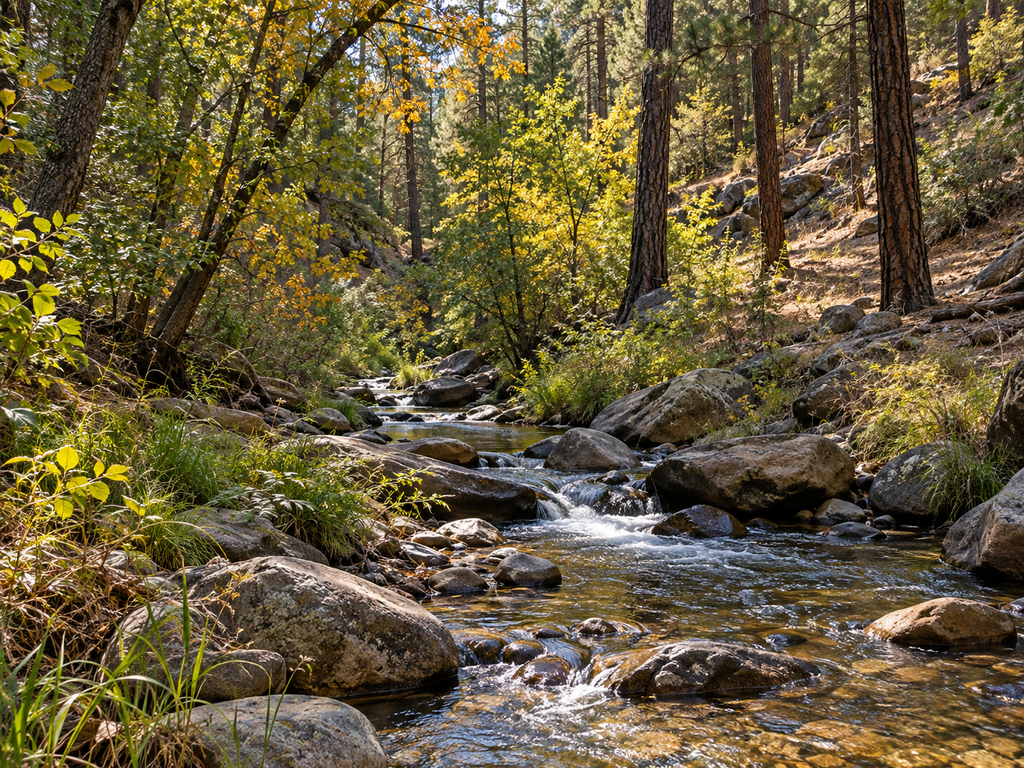

Haigler Creek combines stocked rainbow-trout water with a remote forest-canyon setting east of Payson and north of Young. The practical challenge is not finding a famous trailhead—it is choosing between two unpaved approaches, arriving with enough clearance and supplies, and knowing where the recreation fishery gives way to water managed for native species. This guide focuses on the signed Haigler Canyon Campground and Day Use area, the most clearly verified public access point.
Haigler Creek at a glance
| Planning detail | What to know |
|---|---|
| Verified access | Haigler Canyon Campground and Day Use, Tonto National Forest |
| Fishery | Rainbow trout are periodically stocked from April through late August; wild rainbow trout and native-fish management occur in other reaches |
| Roads | Forest Roads 200 and 291 are unpaved, narrow, winding and steep |
| Facilities | Vault toilets and picnic tables; no potable water |
| Camping | 14 overnight sites in two campground areas; 14-day stay limit; trailers under 20 feet |
| Key hazards | Flash floods, rough roads, winter cold, bears and limited services |
Where to fish without confusing the creek’s management zones
Arizona Game and Fish Department’s Fish & Boat AZ record for Haigler Creek identifies rainbow trout, brown trout, Gila trout and roundtail chub in the drainage. That list does not mean every species occurs at every pullout or that every reach has the same fishing purpose.
The agency’s Arizona Wildlife Conservation Strategy divides Haigler Creek into three management sections. The middle reach—from Gillette Ranch to the natural waterfall below Alderwood Campground—is described as an intensive-use rainbow-trout fishery. The lower reach from that waterfall to Tonto Creek is managed primarily for native aquatic species, including Gila trout. This guide therefore does not present the lower native-species reach as ordinary harvest water.
At the developed Haigler Canyon recreation site, the Forest Service specifically identifies rainbow-trout fishing and says the stream is periodically stocked from April through late August. Fish stocking and catchability can change with water temperature and water quality, so treat the stocking window as a planning clue—not a promise that fish were planted immediately before your visit.
Two rough-road approaches
The official Haigler Canyon Campground and Day Use page gives two approaches. From Payson, travel east on State Route 260 for about 24 miles, turn right on Colcord Road/Forest Road 291 for about three miles, then turn right on Forest Road 200 for about six miles. Continue through the recreation area to Forest Road 202A, then turn right for roughly half a mile to the campground.
From Young, travel north on State Route 288/Forest Road 512 for about three miles, turn left on Forest Road 200, and continue about nine miles. Both routes are unpaved. The Forest Service describes the canyon road as windy, narrow and steep and advises four-wheel drive or chains after heavy rain or snow. Only street-legal off-highway vehicles may use the roads.
Do not let the mileage suggest an easy drive. Storms can turn surfaces muddy, create washouts or make a safe turnaround difficult. Check current Tonto National Forest alerts and weather before leaving pavement, carry a full-size spare, and turn back before road conditions exceed your vehicle or experience.
Parking, campground and day-use facilities
The recreation site contains two independent campground areas with 14 overnight sites and two picnic sites for day use. The Forest Service lists vault toilets and picnic tables but no potable water. Bring all drinking and cooking water, and pack out every item you bring in. Trailers must be under 20 feet, and the stay limit is 14 days.
Official fee guidance is inconsistent. The current Forest Service recreation page says no fees are required, while the Fish & Boat AZ listing says Tonto recreational passes may be required depending on the activity. Because pass rules can change and may vary by site or use, confirm the requirement with the Pleasant Valley Ranger District before the trip rather than relying on an old pass in the glovebox.
Vault toilets do not establish accessible fishing access. I could not verify a step-free creek route, accessible fishing platform or firm-surface path from the official descriptions. Visitors who need those features should contact the district before making the rough drive.
Fishing seasons, license and regulations
The developed site is listed as open year-round, but access and fishing conditions are seasonal. Spring and early summer overlap much of the stated stocking period. Summer monsoons can raise the creek quickly. Autumn can bring cool water and quieter camping, while winter temperatures may fall into the teens and snow can make the roads unsuitable.
Arizona generally requires a fishing license for anglers age 10 and older. The current statewide trout limit applies unless a posted order or special regulation says otherwise. Before fishing, check the latest Arizona fishing regulations, Fish & Boat AZ record and any notices at the site. Release any fish you cannot identify confidently, and do not assume a stocked-water rule applies downstream in the native-species management reach.
How to fish this small creek responsibly
Haigler Creek is compact water where a quiet approach matters more than long casts. Look for shaded pools, current seams beside rocks and undercut banks, but avoid trampling soft banks or cutting through occupied campsites. A short rod and light tackle are easier to control under trees. Keep fish in the water while unhooking them, wet your hands first, and stop fishing when warm or low flows make a safe release doubtful.
- Use only signed public access and respect ranch, tribal and private boundaries.
- Carry pliers or hemostats for quick hook removal.
- Clean, drain and dry boots and tackle before moving to another water.
- Pack out line, hooks, bait containers and all camp trash.
- Keep food and scented items secured in bear-resistant storage.
Flash-flood and backcountry safety
The Forest Service specifically warns that rain on the Mogollon Rim can cause flash flooding in Haigler Canyon. Leave the creek channel immediately if water turns muddy, begins carrying debris or rises unexpectedly—even if the sky directly overhead is clear. Never camp in the drainage bottom or attempt to drive through moving water.
- Tell someone which approach you will use and when you expect to return.
- Download maps before the trip; mobile service may be unreliable.
- Carry extra water, food, warm layers and basic vehicle-recovery gear.
- Watch for slick rocks, falling limbs, wildlife and sudden weather changes.
- Check road and fire restrictions on the morning of departure.
Nearby Mogollon Rim alternatives
If Haigler Creek’s roads are not a good match for your vehicle, compare the access details in the Christopher Creek roadside fishing guide. For a different narrow-stream trip with a clearly defined regulation boundary, use the Canyon Creek O.W. Bridge guide. Both are part of this growing Mogollon Rim waters collection, but each has its own road, access and regulation details.
Trip-planning checklist
- Verify Tonto National Forest alerts, weather and Forest Road conditions.
- Confirm any pass requirement with the Pleasant Valley Ranger District.
- Bring an Arizona fishing license and current regulations.
- Carry all drinking water; none is available at the campground.
- Know which management reach you are fishing.
- Leave before storms threaten the canyon or access roads.


Leave a Reply