
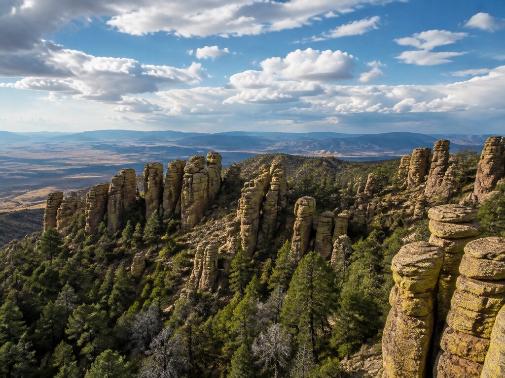
Chiricahua National Monument protects a “Wonderland of Rocks” in southeastern Arizona, where volcanic rhyolite has weathered into towers, balanced formations and narrow passages above oak-and-pine canyons. The monument is remote, free to enter and rewarding by car or on foot—but limited services, high elevation and fast-changing weather make a little preparation especially valuable.
Start at the Visitor Center
Use 13063 E Bonita Canyon Road, Willcox, AZ 85643 for GPS directions to the visitor center. To remain on paved roads, approach via Arizona Highways 186 and 181. Cell service is limited near the monument, so download maps and directions before leaving Willcox or Sunizona.
The monument is open 24 hours, while the visitor center is generally open daily from 8:30 a.m. to 4:30 p.m. Mountain Standard Time. Most of Arizona does not observe daylight saving time. There is no entrance or parking fee, but camping requires a paid reservation.
Drive Bonita Canyon Road to Massai Point
The paved Bonita Canyon scenic drive climbs eight miles from the entrance to Massai Point. Allow at least 60–90 minutes for the round trip with stops. The road passes Faraway Ranch, the visitor center, Bonita Canyon Campground and turnoffs for Echo Canyon and Sugarloaf before ending at a panoramic overlook.
Past the campground, the road is narrow and winding. Vehicles longer than 24 feet are prohibited beyond the campground, and trailers must be disconnected at Faraway Ranch. Vehicles over 29 feet must stop at Faraway Ranch. Snow, ice, rockfall or storm damage can temporarily close the upper drive, so check the current NPS conditions before setting out.
Choose a Hike That Fits Your Day
- Bonita Creek Loop: an easy, paved 0.2-mile loop with picnic tables, parking and a vault toilet. It is the monument’s fully accessible trail and pets are permitted on leash.
- Massai Point Nature Trail: a half-mile interpretive route from the scenic drive’s end. Expect stairs, uneven footing and elevation near 6,870 feet; only the first 0.1 mile is paved.
- Echo Canyon Loop: a moderate 3.4-mile circuit through prominent rock formations, with loose surfaces, steep drop-offs and about 560 feet of total elevation change. Allow roughly two to four hours.
- Heart of Rocks: a strenuous 7.3-mile round trip with rock steps and unusual balanced formations.
- The Big Loop: a strenuous 9.5-mile route combining much of the upper trail system; plan four to seven hours.
The park may offer limited hiker transportation during busy winter periods, subject to staffing and weather. It is not a dependable everyday shuttle, so check the official calendar and plan a route that returns you to your own vehicle unless current service is specifically confirmed.
Camping and Facilities
Bonita Canyon Campground is open year-round by reservation. Standard sites are $25 per night and the tent-only group site is $50. Sites have picnic tables, grills and shared food lockers; flush toilets and potable water are available, but there are no showers or hookups. Up to half the campground may close during the June–September monsoon season because of flood risk.
Bring food, drinking water and fuel before entering the monument. There are no restaurants or gas stations in the park, and roadside assistance may take many hours. The visitor center sells only limited snacks. Fill the tank along Interstate 10 or in a nearby community before making the final approach.
Accessibility and Pet Rules
The visitor center and nearby restrooms are accessible, although its doors do not have automatic openers. Campsite 8 is designated accessible. Bonita Creek picnic area has a hardened route to an accessible vault toilet, and Massai Point offers an accessible picnic table near the parking area. Most upper trails include steps, narrow passages and major elevation changes.
Pets must remain leashed and are not allowed on most trails through the rock formations. Bonita Creek Loop is a notable pet-friendly option. Never leave pets unattended or provide food or water to wildlife.
Elevation, Heat and Monsoon Safety
- Elevation ranges from roughly 5,400 to 7,300 feet. Slow down, hydrate and watch for headache, nausea, fatigue or unusual shortness of breath.
- NPS recommends carrying approximately one liter of water per hour or half a liter per mile, plus electrolytes for longer hikes.
- From July through September, begin early and watch for rapidly developing thunderstorms, lightning and flash-flood danger.
- Winter can bring snow, ice and slippery shaded trails.
- Rabies has been detected in southeastern Arizona. Never approach, feed or touch wild animals; report abnormal behavior and seek immediate medical care after any bite or scratch.
- Fires are prohibited outside Bonita Canyon Campground. Overnight campground guests may use provided grills or shielded on/off cooking devices only when current fire restrictions allow.
- Carry a map, flashlight, sun protection, sturdy footwear, food and basic emergency supplies; cell coverage is unreliable.
- Stay on designated trails and away from cliff edges, loose rocks, cactus and rattlesnakes.
Plan Your Visit
For official hours, closures, trail maps, camping reservations and current alerts, begin with the National Park Service Chiricahua planning guide. A first visit can be as simple as the visitor center, Bonita Canyon Drive, Massai Point and one short trail; stronger hikers can build a full day around Echo Canyon or Heart of Rocks.


Leave a Reply