
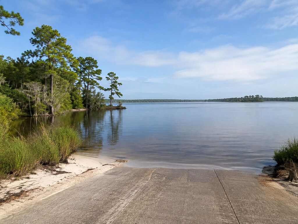
Richardsons Landing is a public Lake Moultrie boat access near Bonneau, South Carolina. South Carolina’s official boat-ramp inventory identifies the site as open and owned and maintained by Santee Cooper. This guide focuses on the details you can verify before towing a boat there: the exact map point, current access record, fishing rules, ramp checks and lake hazards.
Richardsons Landing quick facts
- Official ramp name: Richardsons
- Waterbody: Lake Moultrie
- Area: Bonneau, Berkeley County, South Carolina
- Coordinates: 33.3111, -79.9975
- Owner and maintenance agency: Santee Cooper
- Current dataset status: Open
- SCDNR record: FID 115; Facility ID 8020
Use the SCDNR Boat Ramps dataset as the primary source for the current record. The map at the end of this guide is pinned to the dataset coordinates because the official sources reviewed do not provide a dependable numbered street address.
How to reach the ramp
Navigate to 33.3111, -79.9975 and keep the coordinates available offline. The landing is associated with Bonneau on the eastern side of Lake Moultrie. Do not substitute a similarly named private access or follow an unverified street address. On arrival, obey gates, barriers and posted notices even when an online record says open.
The official ramp record does not specify the number of lanes, parking spaces, courtesy docks or trailer-turning dimensions. Arrive in daylight on a first visit so you can inspect the approach and decide whether your rig can launch and retrieve safely.
Current public-access status and the 2024 dredging work
Santee Cooper describes Richardson Landing as a public landing in Bonneau that it owns and manages. A September 6, 2024 notice announced a temporary closure through the end of that month for excavation and dredging to remove sand buildup at the launch area. That was a time-limited maintenance closure, not a current closure notice. The current SCDNR record lists the landing as open, and no newer official closure notice was found during the September 4, 2026 verification.
Because this ramp has a documented history of sand accumulation, visually check the ramp edge, water depth and trailer path before backing in. That history does not establish that sand is obstructing the ramp today.
Launching and parking checks
- Walk the ramp first and look for sand, soft shoulders, drop-offs or debris.
- Confirm the water beside the ramp is deep enough for your trailer and boat before backing down.
- Keep the staging area clear; load tackle and secure gear before occupying the ramp.
- Park only where signs or marked areas permit, leaving the turnaround open.
- Do not assume restrooms, lighting, potable water, trash service or an accessible boarding feature are available; those facilities were not confirmed by the official sources reviewed.
Conditions can change with lake level, storms and maintenance. If a gate is closed or an agency notice conflicts with this guide, treat the on-site restriction as controlling.
Fishing from Richardson’s side of Lake Moultrie
This landing provides boat access to Lake Moultrie, but a ramp listing does not guarantee productive fishing or safe passage to every area of the lake. Match your tackle and trip plan to current conditions, and review the current SCDNR fishing regulations before leaving home. Carry the required license and verify species limits, seasons and any special rules directly with SCDNR.
Shore-fishing space is not documented in the sources used for this guide. Plan this as a boat-launch destination unless on-site signs clearly identify lawful bank access.
Lake Moultrie navigation and safety
Santee Cooper cautions lake users to follow navigation markers and watch for submerged trees, stumps and floating logs. Markers help define maintained channels, but they do not eliminate hazards. Slow down outside familiar routes, especially in low light or after storms.
- Check wind, thunderstorms and lake conditions before launching.
- Wear a properly fitted life jacket and carry all legally required safety gear.
- Save the ramp coordinates so you can return without relying on cell service.
- Tell someone your route and return time.
- Give dams, spillways, work zones and marked restricted areas a wide berth.
Review Santee Cooper’s current lakes and boating guidance before the trip.
When to go
Daylight is the best choice for a first launch because it makes the ramp approach and unfamiliar lake hazards easier to assess. Summer heat and fast-building thunderstorms reward an early start, while cool-season trips require extra preparation for cold-water exposure. Wind can make open sections of Lake Moultrie rough even when the ramp cove looks calm.
Nearby verified alternatives
If Richardson’s approach is unsuitable for your rig or temporarily restricted, compare two other verified Lake Moultrie launches: Hatchery Landing and Amos Lee Gourdine / Russellville Landing. For access below Wilson Dam, see the separate Wilsons Landing Santee River guide. Each location reaches a different part of the system, so choose by your intended route rather than distance alone.
Plan before you tow
Recheck the official ramp record, weather and regulations shortly before departure. Bring a backup launch, avoid blocking the ramp while inspecting conditions, and never launch past a closure barrier. Richardson’s current open listing and exact coordinates make it a useful eastern Lake Moultrie option, while the documented dredging history makes an on-arrival ramp check especially worthwhile.


Leave a Reply