
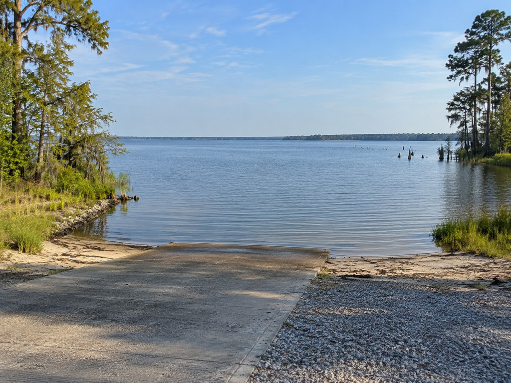
Augustus M. Flood Landing is a public Lake Moultrie boat access near Bonneau, South Carolina. It also appears in older SCDNR material as A. M. Flood Landing (Shrine Club). The current official boat-ramp dataset lists the site as open, owned and maintained by Santee Cooper. This guide gives boaters and anglers the exact map point, source-backed access status, launch checks, fishing context and lake hazards to review before a trip.
Augustus M. Flood Landing quick facts
- Current official ramp name: Augustus M Flood
- Alternate name: A. M. Flood Landing (Shrine Club)
- Waterbody: Lake Moultrie
- County: Berkeley County, South Carolina
- Coordinates: 33.3131, -80.0000
- Owner and maintainer: Santee Cooper
- Current dataset status: Open
- SCDNR record: FID 103; Facility ID 8008
The primary source is the SCDNR Boat Ramps FeatureServer. The map at the end of this article is pinned to its attribute and geometry coordinates. No dependable numbered street address was published in the official sources reviewed.
Which landing name should you use?
Use Augustus M. Flood Landing when matching the current SCDNR dataset. An archived SCDNR boating-inspection notice identifies the same Lake Moultrie site as A. M. Flood Landing (Shrine Club) in Berkeley County. Including both names helps distinguish this access from unrelated Shrine Club ramps elsewhere in South Carolina.
The current dataset names Santee Cooper—not a private club—as owner and maintenance agency and marks the landing open. Always obey gates, barriers and posted notices if on-site conditions differ from an online record.
Directions and first-visit checks
Navigate to 33.3131, -80.0000 and keep the coordinates available offline. The point is on the eastern Lake Moultrie side near Bonneau and very close to Richardsons Landing, so confirm the destination name and pin before turning onto the final approach.
- Arrive in daylight for your first visit.
- Walk the ramp before backing down and check for debris, sand, soft edges or a drop-off.
- Confirm water depth is suitable for your trailer and boat.
- Load gear before entering the launch lane.
- Park only in signed or clearly established areas and keep the turnaround open.
The official records do not specify lane count, parking capacity, courtesy docks, fees, restrooms, lighting or an accessible boarding feature. Treat those items as unverified rather than assuming they are available.
Fishing Lake Moultrie from this access
SCDNR describes Lake Moultrie as a 60,400-acre Berkeley County reservoir with largemouth bass, pickerel, bream, striped bass, blue catfish, flathead catfish and shellcracker fisheries. Conditions and productive areas change by season, weather and water level, so use the landing as an access point—not a guarantee of a particular catch.
Review the 2026–2027 SCDNR fishing regulations before leaving home. Carry the required license and verify current species limits, seasons and tackle restrictions directly with the agency. Shore-fishing space at the ramp was not confirmed, so plan this primarily as boat access unless signs identify lawful bank-fishing areas.
Lake Moultrie navigation hazards
Lake Moultrie is broad, but its gently sloping shallows contain submerged stumps. SCDNR and Santee Cooper both urge caution outside marked navigation channels. Santee Cooper also warns that floating and nearly submerged logs can drift into channels.
- Follow red and green channel markers where a marked route serves your trip.
- Slow down in shallow or unfamiliar water.
- Do not tie to navigation markers.
- Wear a properly fitted personal flotation device.
- Check wind and thunderstorms before launching; open water can become rough quickly.
- Save the landing coordinates and tell someone your route and return time.
Read Santee Cooper’s current lakes, navigation and boating-safety guidance before departure.
Seasonal planning
Early mornings generally offer cooler conditions during late summer, but weather can change quickly. Spring fishing activity can bring heavier ramp traffic. Cool-season boaters should prepare for cold-water exposure even on mild days. After storms, inspect the launch and remain alert for floating debris before committing to open water.
Nearby verified alternatives
Richardsons Landing is the closest separately documented Lake Moultrie alternative and has its own exact official record. You can also compare Hatchery Landing or Amos Lee Gourdine / Russellville Landing. For river access below Wilson Dam, use the separate Wilsons Landing guide.
Choose a backup based on your intended fishing area and safe water route, not simply driving distance.
A practical launch plan
- Recheck the SCDNR ramp record, weather and current regulations.
- Enter the exact coordinates and save a nearby alternate.
- Inspect the ramp, water depth and parking layout on arrival.
- Stage away from the launch lane.
- Use marked channels and conservative speed until you know the area.
Bottom line
Augustus M. Flood Landing is a verified open, Santee Cooper-owned Lake Moultrie ramp with a precise SCDNR map point. Its alternate Shrine Club name is useful for matching older references, but the current official record should lead trip planning. Confirm conditions at the site, bring a backup launch and treat stump-filled shallows with respect.


Leave a Reply