
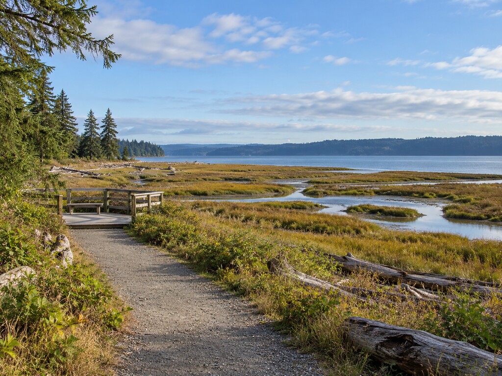
Dosewallips State Park’s signed beach-access trail leads to Hood Canal tide flats, an observation platform and one of WDFW’s specifically inventoried public shellfish beaches. The shoreline remains useful for walking, wildlife watching and learning about the estuary, but harvesting is not allowed now: clams and mussels are closed for all of 2026, oysters are closed by emergency biotoxin rule until further notice, and the marked south section is closed year-round. This guide explains the correct parking area, accessible trail, exact closure boundaries, facilities and safer alternatives.
Dosewallips shellfish beach quick facts
- Official beach record: WDFW site 270200, Dosewallips State Park
- Park address: 306996 Highway 101, Brinnon, WA 98320
- Beach access: Separate signed day-use lot on the Hood Canal side of Highway 101
- Trail: Flat route from the parking lot toward the beach; WDFW describes it as suitable for wheelchair access
- Viewing: Observation platform overlooking the tide flats, Hood Canal and Olympic Mountains
- Parking pass: Discover Pass required
- Clams and mussels: Closed for harvest throughout 2026 because of declining clam abundance
- Oysters: Closed for biotoxins by emergency rule until further notice
- South beach: Closed year-round south of the marked boundary
- Boat launch: None at Dosewallips; Triton Cove State Park is seven miles south
Check the current WDFW Dosewallips State Park beach record immediately before visiting. Emergency health closures can change independently of the annual season.
Use the separate beach-access parking lot
The campground and main park facilities sit near 306996 Highway 101, but WDFW gives more precise instructions for the shellfish beach lot. From Shelton or Olympia, travel north on Highway 101 through Brinnon, cross the Dosewallips River and take the first right. From Port Townsend, Port Angeles or Kitsap County, travel south and take the last left before the Dosewallips River bridge.
The signed day-use lot is north of the campground and just south of the Brinnon Store. Find the beach-access trailhead in the southeast corner of that parking area. Do not improvise roadside parking or cross private property if the turn is missed; continue to a safe place, turn around and approach the marked entrance again.
The trail is accessible; the tide flats may not be
WDFW describes the flat trail between the lot and beach as suitable for wheelchair access. Informational displays stand near the trailhead, and an observation platform provides a broad view over the estuary. The state’s campground map also labels the beach parking and North Tidal Area Trail.
That accessible approach does not make the intertidal surface uniformly accessible. WDFW warns that sticky mud on the beach can be difficult to cross. Stop at the platform or firm trail edge if footing, mobility equipment, tide or surface conditions make the flats unsafe.
Clams and mussels are closed for all of 2026
WDFW’s exact beach record states that the clam and mussel season is closed for harvest in 2026 because clam abundance has declined. This is a conservation closure, not merely a temporary health advisory. Low tide, visible shellfish or activity elsewhere on Hood Canal does not override it.
Walking and wildlife viewing remain possible where park rules allow, but leave clams and mussels undisturbed. Check future annual seasons before planning any harvest because a new calendar year does not automatically guarantee an opening.
Oyster harvest is also closed now
Although WDFW describes Dosewallips as an excellent oyster beach, its current record says the oyster season is closed for biotoxins by emergency rule until further notice. This health closure was still posted on September 12, 2026.
Legal shellfish harvest requires two independent green lights: the WDFW season must be open and the Washington Department of Health status must approve harvest that day. Never use appearance, smell, cooking or a past trip as a safety test for marine biotoxins. Follow the linked DOH status from the WDFW beach page before any future harvest.
The south section is closed year-round
Dosewallips State Park South is closed to shellfish harvest year-round. WDFW defines that section as the beach south of the boundary line marked onsite and says shellfish from that area are not fit for human consumption at any time. Treat the markers—not a phone’s approximate map—as the operative boundary, and respect adjacent private property.
What remains worth doing at the beach
- Walk the flat beach-access trail and stop at the observation platform.
- Watch tidal channels change as Hood Canal rises or falls.
- Look for shorebirds and marine mammals without approaching or feeding wildlife.
- Use the informational displays to understand the estuary.
- Photograph the landscape while staying on durable surfaces.
- Explore the park’s freshwater and forest trails on the campground side of Highway 101.
Washington State Parks describes Dosewallips as a year-round camping park with shoreline on both Hood Canal and the Dosewallips River. Visitors may also encounter elk in and around the campground; remain at least 100 feet away and never offer food.
Hours, pass and facilities
- Summer park hours: 8 a.m. to 10 p.m.
- Winter park hours: 8 a.m. to 5 p.m.
- Parking: Discover Pass required; current listed price is $10 for one day or $45 annually
- Facilities: Restrooms, showers, potable water, year-round camping and picnic areas
- Nearby services: WDFW notes a convenience store and two cafés within a short distance
Confirm hours, campground availability and alerts on the official Washington State Parks page. A Level 3 burn ban was active September 12, 2026: no charcoal or wood fires; self-contained gas or propane equipment is allowed only where the park permits it.
Estuary and river safety
- Check the tide before stepping beyond the viewing platform; water can isolate low areas and muddy channels.
- Do not enter sticky mud that could trap footwear or mobility equipment.
- Keep children away from steep channel edges and swift river water.
- The park has no formal swimming area; State Parks warns that the Dosewallips River can be swift and unsuitable for young children.
- Give elk and all wildlife at least 100 feet of space.
- Carry layers and rain protection; Hood Canal weather can change quickly.
- Stay within marked public access and leave shellfish undisturbed during closures.
No boat launch at Dosewallips
Despite the shoreline setting, Dosewallips State Park does not provide a watercraft launch. Washington State Parks directs boaters seven miles south to Triton Cove State Park. The Triton Cove boat-launch guide covers its accessible ramp, seasonal 100-foot handling dock, trailer parking and launch-pass requirements.
For a future shellfish trip, WDFW identifies Quilcene Bay WDFW Tidelands and Duckabush as nearby alternatives, but each beach has its own season, boundary and daily DOH health status. Verify both agencies before collecting anything; “open year-round” in a season table does not cancel an emergency biotoxin closure.
Visit the estuary without treating it as an open harvest
Dosewallips remains a useful precise destination even during the closures: the signed day-use lot, flat trail, observation platform and tidal landscape make a practical short stop in Brinnon. The essential planning distinction is simple—beach access remains available, but clam, mussel and oyster harvest is closed. Use the trail, watch the wildlife, respect the marked south boundary and check official status before every visit.


Leave a Reply